GeoPlant


Henning Larsen, R&D
Copenhagen with a global target, 2023
Open-source plant database
Funded by the Ramboll Foundation & Henning Larsen
Role: Project manager, UI/UX, Web development
︎︎︎Henning Larsen’s article about GeoPlant
Optimizing biodiversity-centred design, the new digital tool holds a wealth of global vegetation knowledge and data, providing designers with the means to prioritize native flora in projects.
Biodiversity is declining faster than any other period in human history. For years, humans have introduced foreign and invasive species around the world devastating local ecosystems. Native flora are essential in maintaining ecological balance, providing food and habitats to wildlife, and supporting the intricate relationships that maintain ecosystem health and stability.
Designing spaces that protect and restore indigenous flora is critical to combat the biodiversity crisis. GeoPlant, developed with a team of design experts, biologists, and ecologists, streamlines the design process by digitalizing typically fragmented knowledge. Until recently, digital tools have been absent in landscape design, where books have traditionally dominated the input stream. GeoPlant bridges this gap by converting extensive flora data and knowledge into a digital format, transforming plant selection into a shared, performance-based choice. The tool uses smart technology to understand ecological conditions, enabling users to work more efficiently across different geographies and climate zones.
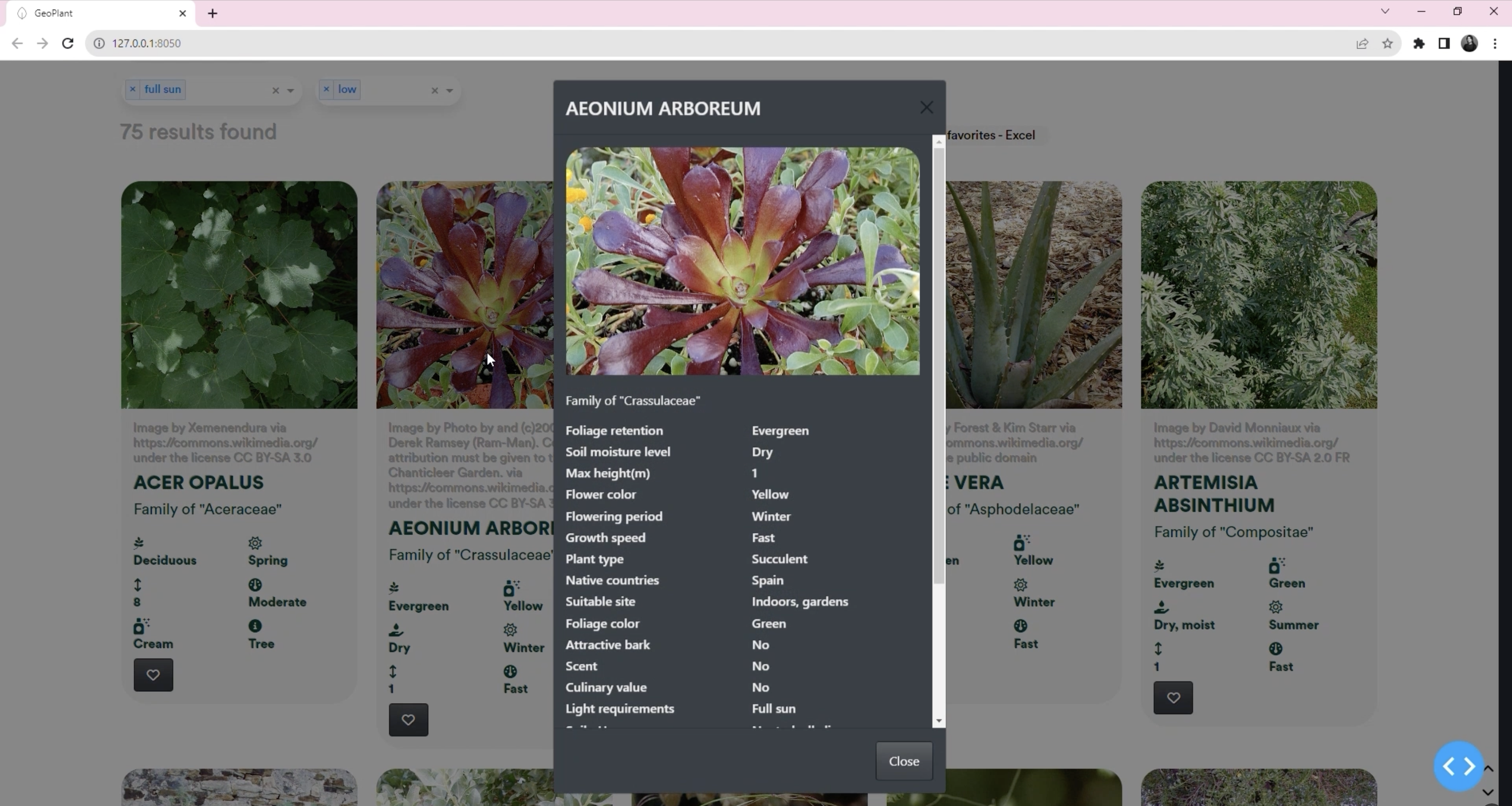
The new tool includes 5,600 plant species gathered from over six sources with 62 features and details attributed to every individual flora. The filters are categorized into general traits, human factors, functionality, productivity, environmental conditions, structure, sensorial aspects, and durability offering a well-rounded holistic perspective. This simplifies the process of selecting plants, allowing users to easily find species based on location, project type, or specific features.
When constructing GeoPlant, a variety of vegetation data was collected across global offices, to develop a solid foundation to build the tool. Based on the data collection, the team ideated GeoPlant and the database criteria. It was facilitated by an iterative process in which the team selected, re-grouped, defined, and categorized data.
With GeoPlant, various questions can be explored and answered on the spot such as:
Copenhagen with a global target, 2023
Open-source plant database
Funded by the Ramboll Foundation & Henning Larsen
Role: Project manager, UI/UX, Web development
︎︎︎Henning Larsen’s article about GeoPlant
Optimizing biodiversity-centred design, the new digital tool holds a wealth of global vegetation knowledge and data, providing designers with the means to prioritize native flora in projects.
Biodiversity is declining faster than any other period in human history. For years, humans have introduced foreign and invasive species around the world devastating local ecosystems. Native flora are essential in maintaining ecological balance, providing food and habitats to wildlife, and supporting the intricate relationships that maintain ecosystem health and stability.
Designing spaces that protect and restore indigenous flora is critical to combat the biodiversity crisis. GeoPlant, developed with a team of design experts, biologists, and ecologists, streamlines the design process by digitalizing typically fragmented knowledge. Until recently, digital tools have been absent in landscape design, where books have traditionally dominated the input stream. GeoPlant bridges this gap by converting extensive flora data and knowledge into a digital format, transforming plant selection into a shared, performance-based choice. The tool uses smart technology to understand ecological conditions, enabling users to work more efficiently across different geographies and climate zones.
The new tool includes 5,600 plant species gathered from over six sources with 62 features and details attributed to every individual flora. The filters are categorized into general traits, human factors, functionality, productivity, environmental conditions, structure, sensorial aspects, and durability offering a well-rounded holistic perspective. This simplifies the process of selecting plants, allowing users to easily find species based on location, project type, or specific features.
When constructing GeoPlant, a variety of vegetation data was collected across global offices, to develop a solid foundation to build the tool. Based on the data collection, the team ideated GeoPlant and the database criteria. It was facilitated by an iterative process in which the team selected, re-grouped, defined, and categorized data.
With GeoPlant, various questions can be explored and answered on the spot such as:
Which shrubs are native to Singapore and have yellow flowering?
Which plants can remove pollutant such as nitrogen and are natural to the USA?
Which trees have a minimum height of 4m and require fertile or silty soil?
Which plants are native to Spain, have low watering needs and thrive in full sun condition?
Which plants climber plants have a scent?